 Skip to content
Crop monitoring is a vital practice in modern agriculture, involving the continuous observation and analysis of crop growth, health, and development. It helps farmers identify issues early, optimize resource use, and improve yields. Thanks to technological advancements, crop monitoring has evolved from manual field inspections to sophisticated methods powered by drones and remote sensing.
One of the most transformative innovations in this field is the use of drones for crop health analysis, pest detection, and yield forecasting. These aerial devices provide detailed imagery and data that enable precision farming, reducing waste and increasing productivity. Understanding how to leverage drone technology for crop monitoring opens up new opportunities for sustainable and efficient agriculture.
In this article, we will explore the core concepts of crop monitoring, walk through practical drone applications, examine the benefits and limitations, and share best practices to maximize the advantages of this technology in your agricultural operations.
Understanding Crop Monitoring and Its Core Concepts
What Crop Monitoring Entails
Crop monitoring involves the systematic tracking of crop conditions throughout the growing season. This includes assessing plant health, growth stages, nutrient levels, water stress, and pest infestations. Traditionally, this was done through manual scouting, which is time-consuming and prone to errors. Modern crop monitoring integrates technology to gather accurate, real-time data efficiently.
Farmers use this information to make informed decisions about irrigation, fertilization, pest control, and harvesting. This proactive approach helps prevent losses and enhances crop quality. The goal is to maintain optimal growing conditions for maximum yield and sustainable resource use.
By continuously monitoring crops, farmers can detect subtle changes that might indicate disease or nutrient deficiencies before they become severe. This early detection is crucial for timely intervention and better crop management.
Key Technologies Behind Crop Monitoring
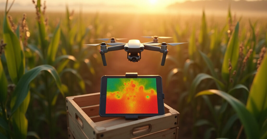
Technologies such as remote sensing, satellite imagery, and drones are revolutionizing crop monitoring. Drones, in particular, offer unparalleled flexibility and resolution in capturing crop data. Equipped with multispectral, thermal, or RGB cameras, drones can scan large fields quickly and deliver precise, actionable insights.
These technologies enable the collection of data on plant vigor, chlorophyll content, moisture levels, and pest presence. Integration with GPS and GIS systems allows for spatial analysis, helping farmers understand variability within their fields and apply treatments selectively.
Data from these sources feed into crop models and analytics platforms, supporting predictive insights and better farm management. This blend of hardware and software marks a shift towards smarter, data-driven farming.
Important Terms to Know
- NDVI (Normalized Difference Vegetation Index): A key indicator derived from multispectral images to assess plant health.
- Multispectral Imaging: Captures light beyond visible wavelengths to reveal crop stress or disease.
- Thermal Imaging: Detects temperature variations indicating water stress or pest activity.
- Precision Agriculture: Farming management concept based on observing and responding to field variability.
- GIS (Geographic Information System): Software for mapping and analyzing spatial data from crops.
Implementing Drone-Based Crop Monitoring: A Practical Guide
Planning Your Drone Flight
Before launching your drone for crop monitoring, proper planning is essential. Start by defining the objectives: Are you looking to assess plant health, detect pests, or forecast yield? Knowing this helps determine the flight path, altitude, and sensor types needed.
Check local regulations and obtain necessary permissions to fly drones over agricultural land. Ensure the weather conditions are favorable—clear skies and low wind improve data quality. Planning also involves setting up the drone software for autonomous flight to cover the entire field efficiently.
Preparing your drone by calibrating sensors and batteries ensures smooth operation. The better the preparation, the higher the quality of data collected during the flight.
Collecting and Processing Data
During the flight, drones capture high-resolution images and sensor data, often in multispectral bands. This raw data requires processing using specialized software that stitches images together and applies algorithms to generate vegetation indices like NDVI.
Post-processing transforms visual data into actionable maps highlighting stressed areas, pest outbreaks, or nutrient deficiencies. These outputs allow for targeted interventions, saving time and resources compared to blanket treatments.
Regular data collection and comparison over time help track crop progress and assess the effectiveness of management strategies, enabling continuous improvement.
Integrating Drone Data with Farm Management Systems
Once processed, drone data can be integrated with farm management software or precision agriculture platforms. This integration helps visualize field variability and plan precise applications of water, fertilizers, or pesticides.
Farmers can generate detailed reports, schedule interventions, and monitor outcomes all within one digital ecosystem. This connectivity streamlines decision-making and promotes sustainable practices by reducing overuse of inputs.
Bringing drone data into existing workflows maximizes its value, turning aerial imagery into practical farming intelligence.
- Define monitoring goals and select sensors.
- Obtain permissions and check weather conditions.
- Plan flight paths covering entire fields.
- Conduct drone flights and capture data.
- Process images and generate vegetation indices.
- Integrate results into farm management tools.
| Monitoring Method | Advantages | Limitations |
|---|---|---|
| Manual scouting | Low cost, direct observation | Time-consuming, subjective, limited coverage |
| Satellite imagery | Large area coverage, frequent updates | Lower resolution, affected by clouds |
| Drone monitoring | High resolution, flexible timing, multispectral data | Requires investment, operational expertise |
Advantages of Drone-Assisted Crop Health Analysis
Enhanced Pest and Disease Detection
Drones equipped with multispectral and thermal sensors can detect early signs of pest infestation and disease outbreaks before visible symptoms appear. This early warning system enables farmers to intervene promptly, reducing crop damage and minimizing pesticide use.
By pinpointing affected zones, treatments can be localized, enhancing effectiveness and lowering costs. This precision reduces environmental impact and preserves beneficial insects and microorganisms within the ecosystem.
Early detection through drones leads to healthier crops and ultimately better yields, making it a game-changer in integrated pest management strategies.
Improved Yield Forecasting Accuracy
Accurate yield forecasting has always been challenging due to environmental variability and unpredictable factors. Drones help by providing detailed spatial data on crop vigor, biomass, and health status, which feed into sophisticated yield models.
This data-driven approach improves the reliability of forecasts, assisting farmers and agribusinesses in planning harvests, storage, and marketing. According to a study by USDA, drone-assisted yield prediction can improve accuracy by up to 20% compared to traditional methods.
Better forecasts reduce financial risks and enable more efficient supply chain management, benefiting the entire agricultural value chain.
Resource Optimization and Sustainability
Drone-based crop monitoring supports precision agriculture by helping farmers optimize input use. By identifying variability in crop needs, water, fertilizer, and pesticides can be applied selectively rather than uniformly. This targeted approach conserves resources and lowers operational costs.
Besides economic benefits, reducing chemical inputs lessens environmental pollution and promotes soil and water health. Sustainable farming practices supported by drone monitoring contribute to long-term farm viability and food security.
Incorporating drones into crop management aligns agricultural productivity with environmental stewardship, a win-win for farmers and the planet.
- Early pest and disease detection
- Improved yield prediction accuracy
- Precise input application
- Cost savings on resources
- Reduced environmental impact
- Enhanced decision-making speed
Challenges and Limitations of Crop Monitoring with Drones
High Initial Investment and Operational Costs
Acquiring drones equipped with advanced sensors and software can be costly, posing a barrier for small and medium-sized farms. Besides hardware, there are costs associated with training, maintenance, and data processing subscriptions.
These upfront expenses require careful consideration and planning to justify the return on investment. However, as technology matures, prices are gradually decreasing, making drone monitoring more accessible.
Farmers should evaluate costs against expected efficiency gains and yield improvements to make informed decisions about adoption.
Regulatory and Privacy Concerns
Drone operations are subject to aviation laws and privacy regulations that vary by country and region. Restrictions on flight altitude, no-fly zones, and data management can complicate drone usage in agriculture.
Compliance with these rules demands awareness and sometimes bureaucratic processes, which could delay or restrict monitoring activities. Additionally, concerns about data privacy and ownership must be addressed transparently with stakeholders.
Staying informed on legal frameworks and adopting best practices helps ensure responsible drone use and fosters trust within communities.
Technical Challenges and Data Complexity
Operating drones and interpreting multispectral or thermal images require technical skills that farmers may lack. Data processing involves complex algorithms and software tools that need training and experience to use effectively.
Incorrect data interpretation can lead to poor management decisions, negating the benefits of drone monitoring. Integrating drone data with other farm information systems also presents challenges related to compatibility and data standardization.
Investing in user-friendly platforms and training programs can help bridge this knowledge gap and unlock the full potential of drone technology.
- High upfront and operational costs
- Regulatory restrictions and compliance
- Complex data processing requirements
- Technical skill barriers for users
- Potential privacy and data security issues
| Aspect | Advantages | Disadvantages |
|---|---|---|
| Cost | Long-term savings on inputs | High initial investment |
| Data Quality | High-resolution imagery | Requires technical expertise |
| Regulation | Enables precision farming | Subject to flight restrictions |
Best Practices for Effective Crop Monitoring Using Drones
Regular and Consistent Data Collection
To fully benefit from drone-assisted crop monitoring, data collection should be regular and consistent throughout the crop cycle. This allows for trend analysis and early detection of anomalies, helping farmers respond proactively.
Scheduling flights at key growth stages and under similar environmental conditions improves data comparability. Consistency also aids in building robust datasets for machine learning models that enhance decision support.
Developing a monitoring calendar aligned with crop phenology ensures timely insights and maximizes the value of drone technology.
Training and Skill Development
Investing in proper training for drone pilots and data analysts is essential. Understanding drone operation, sensor capabilities, and image interpretation empowers farmers and agronomists to use the technology confidently and effectively.
Workshops, online courses, and partnerships with service providers can help build these skills. Additionally, staying updated on technological advancements ensures users leverage the latest tools and methods.
Empowered teams translate technical data into practical agronomic actions that improve crop outcomes.
Choosing the Right Tools and Software
Selecting drones, sensors, and software that match farm size, crop type, and monitoring goals is crucial. Some drones specialize in multispectral imaging, while others might be better suited for thermal or RGB data.
Software platforms vary in user-friendliness, data processing speed, and integration capabilities with farm management systems. Trialing different options and seeking expert advice helps identify solutions that fit specific needs.
Balancing performance, cost, and ease of use prevents underutilization and ensures a positive return on investment.
- Establish a regular flight schedule
- Provide comprehensive training programs
- Select sensors based on crop requirements
- Use user-friendly data processing software
- Maintain drones and calibrate sensors frequently
- Ensure compliance with local regulations
- Integrate data with farm management systems
Emerging Trends and Future of Crop Monitoring
AI and Machine Learning Integration
The incorporation of artificial intelligence (AI) and machine learning is transforming crop monitoring by automating data analysis. Algorithms can identify patterns, predict pest outbreaks, and recommend precise interventions without manual input.
This reduces the time from data collection to decision-making and increases accuracy by learning from historical data. AI-driven insights help farmers optimize operations at an unprecedented scale.
As these technologies mature, they will become essential components of smart farming ecosystems.
Swarm Drone Technology
Swarm drone systems, where multiple drones operate collaboratively, promise to cover large agricultural areas faster and with higher efficiency. This approach reduces flight time and increases data resolution by coordinating sensors and flight paths.
Swarm technology is still in development but is expected to revolutionize large-scale crop monitoring by providing continuous, high-density data streams.
This innovation will enable more dynamic and responsive crop management strategies.
Integration with IoT and Sensor Networks
Combining drone data with Internet of Things (IoT) devices and ground sensors creates a comprehensive monitoring network. Soil moisture sensors, weather stations, and drones form a feedback loop that provides holistic insights into crop conditions.
This integrated system supports precision irrigation, fertilization, and pest control with real-time responsiveness. Farmers gain a 360-degree view of their fields, improving sustainability and productivity.
The future lies in connected, data-rich environments that empower smarter agriculture.
- Automated AI-powered data analysis
- Collaborative swarm drone flights
- Integration with IoT sensor networks
- Real-time monitoring and alerts
- Enhanced predictive modeling
- Lower costs through technology advances
| Emerging Technology | Potential Benefit | Current Status |
|---|---|---|
| AI and Machine Learning | Faster, more accurate analysis | Increasing adoption |
| Swarm Drones | Improved coverage and efficiency | Experimental stage |
| IoT Integration | Holistic farm monitoring | Growing implementation |
Crop monitoring with drones is not just a technological upgrade—it’s a paradigm shift in how we approach farming. By embracing these tools, farmers can enhance productivity, reduce environmental impact, and build resilience against climate variability. The future of agriculture is airborne, data-driven, and more connected than ever.
Frequently Asked Questions about Crop Monitoring
What is crop monitoring?
Crop monitoring refers to the continuous observation and measurement of crop health, growth, and environmental conditions to ensure optimal development. It involves using various tools, such as drones, satellite imagery, and sensors, to detect issues like pests, diseases, and nutrient deficiencies early, enabling timely interventions and improved yields.
How does drone-based crop monitoring work?
Drones equipped with cameras and sensors fly over fields to capture high-resolution images and data across different wavelengths. This information is processed to create maps showing plant health indicators, pest presence, or water stress. Farmers analyze these maps to make precise management decisions, optimizing inputs and preventing crop losses.
What is the difference between drone monitoring and satellite imagery?
Drone monitoring offers higher resolution images and flexible flight scheduling, allowing detailed, real-time data collection at field scale. Satellite imagery covers larger areas but often has lower resolution and is affected by weather conditions like clouds. Drones provide more precise insights, especially for small to medium farms.
When should I use drone monitoring for my crops?
Drone monitoring is most beneficial during critical growth stages when crops are vulnerable to stress, pest attacks, or diseases. Regular flights throughout the growing season, especially during early detection phases, help maintain crop health. It’s also valuable before harvest for yield estimation and final assessments.
How much does drone crop monitoring cost?
The cost varies depending on drone type, sensor quality, software, and farm size. Basic drone setups start around $1,000–$5,000, while advanced multispectral drones can exceed $20,000. Additionally, data processing and training may incur extra expenses. Many farmers opt for service providers to reduce initial investment.
