Advertisements

In today’s rapidly evolving agricultural landscape, agriculture drones are becoming indispensable tools for modern farmers. These unmanned aerial vehicles offer a bird’s-eye view of crops, allowing for precise monitoring, data collection, and targeted interventions. Their ability to enhance farming productivity while reducing costs has made them a game-changer in the industry.
Farmers face numerous challenges, from unpredictable weather to pest infestations and resource management. Agriculture drones address these issues by providing real-time insights and automating several labor-intensive tasks. This technology creates opportunities for smarter decision-making and sustainable farming practices.
In this article, we’ll explore a comprehensive overview of agriculture drones, diving into their basic concepts, practical applications, benefits, limitations, and best practices to help you harness their full potential. Whether you’re a seasoned farmer or just curious about the future of agriculture, this guide has something for you.
Understanding Agriculture Drones: Definitions and Core Concepts
The Essence of Agriculture Drones
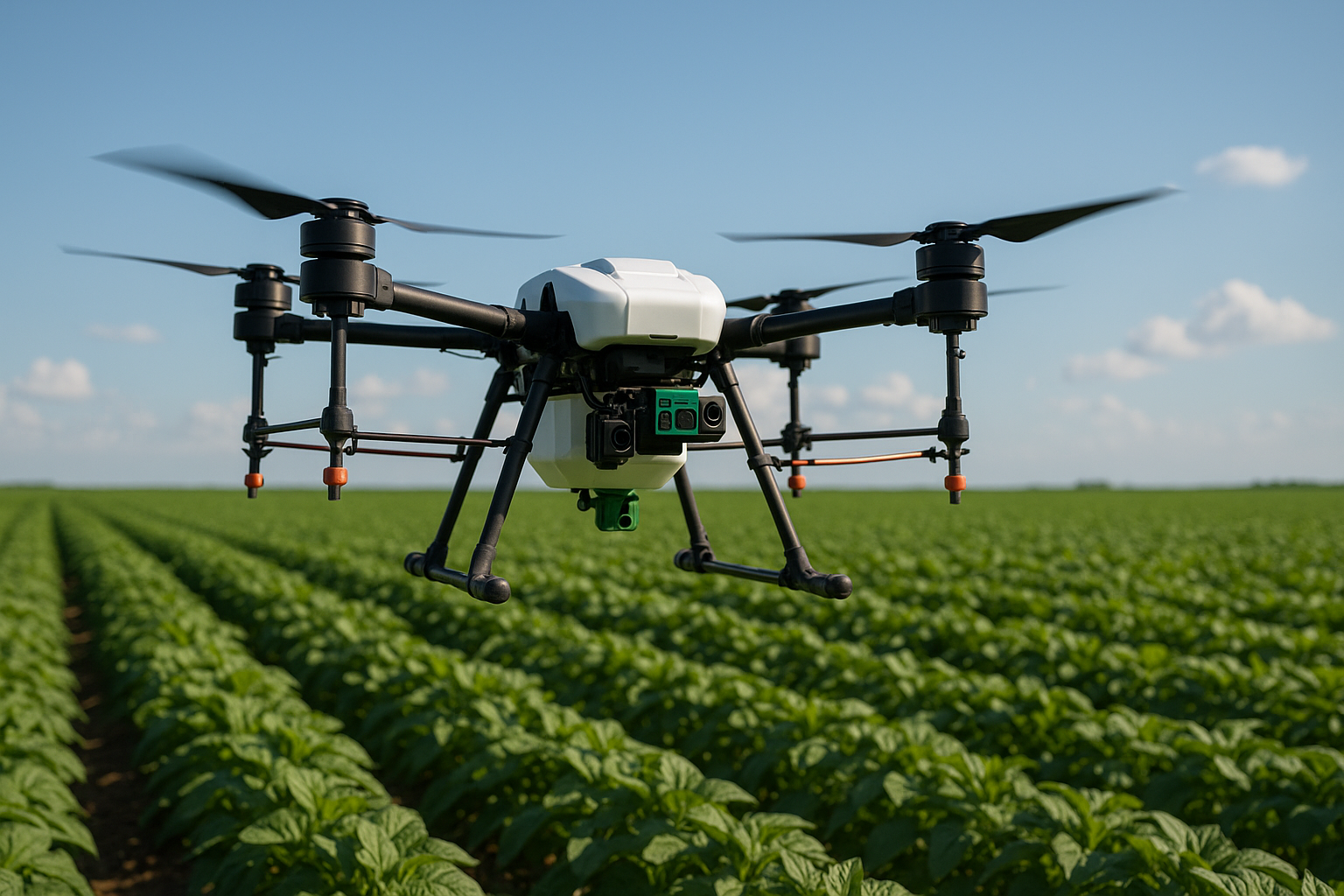
Agriculture drones are specialized unmanned aerial vehicles designed to assist in various farming operations. Equipped with advanced sensors and cameras, they capture detailed imagery and data from above fields, enabling farmers to monitor crop health, soil conditions, and irrigation efficiency. Unlike traditional methods, drones provide quick, accurate data without disturbing the crops.
These drones vary in size and capability, from small quadcopters to larger fixed-wing models designed for extensive coverage. Their adaptability to different farming scales makes them suitable for small organic farms as well as large commercial operations. The technology integrates seamlessly with precision agriculture techniques, improving overall crop management.
By offering real-time aerial insights, agriculture drones empower farmers to respond promptly to issues like pest outbreaks or nutrient deficiencies. This proactive approach helps maximize yields and resource efficiency, ultimately enhancing farm profitability.
Key Technologies Behind Agriculture Drones
The core technology enabling agriculture drones includes GPS navigation systems, multispectral and thermal cameras, and advanced software for data analysis. GPS allows drones to follow pre-programmed flight paths, ensuring consistent coverage of large fields. Multispectral sensors detect plant health indicators invisible to the naked eye by analyzing light reflectance in various spectral bands.
Thermal imaging helps identify irrigation problems by revealing temperature differences across the field. These technologies together provide a multilayered understanding of crop and soil conditions. Additionally, AI-powered software can process and interpret the collected data, generating actionable insights for farmers.
The integration of cloud computing enables data storage and sharing across devices, facilitating collaborative decision-making. The continuous evolution of drone hardware and software expands their capabilities, making them indispensable tools in modern agriculture.
Core Uses of Agriculture Drones in Farming
- Crop health monitoring through multispectral imaging
- Soil and field analysis for precise resource allocation
- Irrigation management using thermal sensors
- Pest and disease detection to enable targeted treatment
- Mapping and creating detailed field models
- Spraying fertilizers and pesticides with improved accuracy
Implementing Agriculture Drones: Step-by-Step Practical Guide
Planning and Preparing for Drone Deployment
Successful integration of agriculture drones starts with careful planning. Farmers should first assess their field size, crop type, and specific needs to select an appropriate drone model. Establishing clear goals, such as reducing pesticide use or improving irrigation, helps tailor drone operations for maximum impact.
Next, it’s essential to understand local regulations regarding drone flights, including no-fly zones and altitude restrictions. Obtaining necessary permits and ensuring compliance prevent legal issues. Training operators or hiring certified pilots guarantees safe and effective drone use on the farm.
Finally, investing in compatible software and hardware accessories, like batteries and sensors, ensures smooth operations. Preparing a flight schedule based on crop cycles and weather forecasts optimizes data collection and treatment timing.
Advertisements
Executing Drone Flights and Data Collection
- Charge drone batteries fully and ensure all sensors are calibrated.
- Program the drone’s flight path using GPS-based mapping software.
- Conduct pre-flight safety checks, including weather and airspace conditions.
- Launch the drone and monitor flight progress remotely, adjusting as needed.
- Download and back up captured data immediately after flight completion.
Following these steps helps maintain operational efficiency and data accuracy. Consistent monitoring during flights ensures the drone covers the entire target area without interruptions. Quick data backup prevents loss and prepares for timely processing.
Processing and Utilizing Agricultural Drone Data
Once data is collected, it must be processed using specialized software that translates images into meaningful insights. Algorithms analyze crop vigor, detect anomalies, and generate field maps highlighting areas needing attention. This analysis allows for precise applications of water, fertilizers, or pesticides.
Farmers can integrate drone data with other farm management systems, creating comprehensive reports that inform strategic decisions. Over time, tracking these metrics helps identify trends and optimize farming practices. The data-driven approach leads to more sustainable and cost-effective operations.
Regularly updating software and maintaining hardware ensures continued accuracy and efficiency. Partnering with agronomists and data specialists can further enhance interpretation and application of drone-derived information.
| Method | Coverage Area | Cost Range |
|---|---|---|
| Manual Field Inspection | Limited to walkable areas | Low (labor intensive) |
| Satellite Imagery | Large-scale | Moderate to high (subscription based) |
| Agriculture Drones | Medium to large fields | Moderate (initial investment with long-term savings) |
The Benefits of Using Agriculture Drones in Farming
Boosting Farming Productivity
Agriculture drones significantly enhance productivity by enabling precise monitoring and targeted interventions. By identifying stressed crops early, farmers can apply treatments only where necessary, preventing yield losses. This precision reduces the guesswork traditionally involved in crop management.
The ability to cover large areas quickly means more frequent assessments and timely responses. According to a study by the USDA, farmers using drone technology reported a 15% increase in crop yields due to improved pest and nutrient management. This boost in productivity directly translates to higher profitability and food security.
Moreover, drones facilitate data-driven planning for crop rotation and planting schedules, further optimizing farm outputs. The integration of drone insights into strategic farm management supports sustainable growth and resilience against environmental challenges.
Reducing Operational Costs
One of the most attractive advantages of agriculture drones is cost reduction. Traditional farming methods often require extensive manual labor and heavy use of inputs like water and chemicals. Drones minimize waste by enabling targeted applications, which lowers input costs significantly.
Additionally, drones reduce the need for manual scouting, decreasing labor hours and associated expenses. A report by AgFunder News highlights that farms employing drones saved up to 20% on pesticide and fertilizer costs annually. These savings can be reinvested into other areas of the farm or improve overall margins.
Furthermore, timely detection of issues such as pest infestations prevents large-scale damage, avoiding costly recovery efforts. The economic benefits create a compelling case for adopting drone technology across diverse farming operations.
Enhancing Strategic Farm Management
- Improved decision-making through real-time data
- Efficient resource allocation based on precise field analysis
- Better risk management with early problem detection
- Integration with precision agriculture platforms
- Scalable solutions for farms of all sizes
- Support for sustainable and environmentally friendly practices
- Facilitates compliance with regulatory standards
Challenges and Limitations of Agriculture Drones
Technical and Operational Constraints
Despite their advantages, agriculture drones have technical limitations. Battery life restricts flight time, often limiting coverage per session to 20-40 minutes. This constraint necessitates multiple flights or additional batteries for larger farms, impacting operational efficiency.
Weather conditions also affect drone performance; strong winds, rain, or fog can ground drones or compromise data quality. Additionally, the need for skilled operators to manage flights and interpret data can be a barrier for some farmers.
Maintenance and calibration of sensors require ongoing attention to ensure accurate results. Without proper upkeep, drones may deliver inconsistent or misleading information, undermining their value.
Regulatory and Privacy Issues
Drone operations are subject to strict regulations in many countries. Farmers must navigate complex legal frameworks concerning flight permissions, altitude limits, and privacy concerns. Failure to comply can lead to fines or restrictions on drone use.
Privacy issues arise when drones fly over neighboring properties, potentially capturing sensitive information. Addressing these concerns requires clear communication and adherence to local laws. In some regions, obtaining necessary certifications for commercial drone use adds time and cost.
These regulatory hurdles may slow adoption, especially among smaller farms or those unfamiliar with drone technology. Staying informed about evolving legislation is crucial for safe and legal drone deployment.
Cost and Accessibility Barriers
- High initial investment for quality drones and sensors
- Ongoing costs for maintenance, software subscriptions, and training
- Limited accessibility in remote or low-infrastructure areas
- Potential technological complexity deterring less tech-savvy farmers
| Aspect | Advantages | Disadvantages |
|---|---|---|
| Cost | Long-term savings on inputs | High upfront purchase price |
| Data Accuracy | Precise crop and soil analysis | Data quality affected by weather and maintenance |
| Regulation | Improved compliance tracking | Complex legal requirements |
| Operation | Automation reduces labor | Requires skilled operators |
Maximizing the Use of Agriculture Drones: Tips and Best Practices
Choosing the Right Drone for Your Farm
Selecting a drone that fits your farm’s size, crop type, and budget is vital. For smaller farms, compact quadcopters with basic sensors may suffice. Larger operations benefit from fixed-wing drones offering extended flight time and greater coverage. Prioritize drones with multispectral and thermal imaging capabilities for comprehensive analysis.
Look for models with reliable battery life, easy-to-use software, and strong customer support. Evaluating user reviews and consulting with agricultural drone experts can help narrow your options. Investing wisely upfront ensures you get the most value and performance from your drone.
Remember to factor in future scalability and compatibility with your existing farm management systems to avoid costly upgrades later.
Maintaining and Calibrating Equipment
Regular maintenance keeps drones operating at peak efficiency. This includes cleaning sensors, checking propellers for damage, and updating firmware. Calibration of cameras and GPS systems ensures precise data collection, which directly impacts decision-making quality.
Develop a maintenance schedule aligned with usage frequency to avoid unexpected downtime during critical farming periods. Keep spare parts on hand to expedite repairs. Training staff or operators in basic troubleshooting can save time and reduce costs.
Proper storage, especially in extreme weather conditions, prolongs drone lifespan and performance. Consistent upkeep is a small investment compared to the benefits it delivers.
Integrating Drone Data into Farm Management
- Use user-friendly software for data visualization
- Combine drone insights with soil and weather data
- Share results with agronomists for expert advice
- Schedule regular drone flights aligned with crop cycles
- Train staff on interpreting and acting on data
- Keep detailed records to track improvements over time
Future Trends and Innovations in Agriculture Drone Technology
Advancements in AI and Machine Learning
The integration of AI and machine learning is transforming agriculture drones into smarter, more autonomous tools. These technologies enable drones to analyze data onboard, recognize patterns, and make real-time decisions without human intervention. This reduces the time between data collection and actionable insights.
For example, AI-powered drones can detect pest infestations earlier and recommend precise treatment plans. Machine learning algorithms improve over time by learning from past data, increasing accuracy and efficiency. These innovations promise to further boost farm productivity and sustainability.
As AI capabilities expand, we can expect drones to play an increasingly strategic role in farm management, shifting from data gatherers to intelligent advisors.
Enhanced Multispectral and Hyperspectral Imaging
Emerging imaging technologies will provide even more detailed insights into crop health and soil conditions. Hyperspectral cameras capture hundreds of narrow wavelength bands, revealing subtle variations in plant physiology that multispectral sensors might miss. This precision allows farmers to detect stress factors earlier and tailor interventions more effectively.
Improved imaging resolution and faster data processing will enable near real-time monitoring of large farms. These advancements will support precision agriculture’s goals of maximizing output while minimizing environmental impact.
Farmers adopting these cutting-edge sensors will gain competitive advantages through superior crop management and resource efficiency.
Integration with Autonomous Machinery
- Linking drones with autonomous tractors and sprayers
- Enabling fully automated planting and harvesting processes
- Real-time monitoring and adjustment of farm machinery operations
- Reducing human labor and errors through synchronized systems
- Enhancing overall farm productivity and sustainability
Conclusion
Agriculture drones are revolutionizing farming by delivering precise, timely data that enhances productivity, reduces costs, and supports strategic management. From detailed crop monitoring to automated treatment applications, these tools empower farmers to make smarter decisions and improve sustainability. While challenges like regulatory hurdles and technical limitations exist, the benefits far outweigh the obstacles for most operations.
As drone technology continues to evolve, integrating AI and advanced imaging will unlock even greater potential. For farmers ready to embrace innovation, agriculture drones offer a promising path toward more efficient and profitable farming. Why wait to harness the future of agriculture? Start exploring how agriculture drones can transform your farm today.
Frequently Asked Questions
What are agriculture drones?
Agriculture drones are unmanned aerial vehicles equipped with sensors and cameras specifically designed for farming tasks. They capture detailed images and data from fields to monitor crop health, soil conditions, and irrigation. This information helps farmers make informed decisions to improve crop yields and reduce resource waste.
How do agriculture drones work?
These drones fly over fields following programmed GPS routes, capturing multispectral and thermal images. The data collected is then processed using specialized software that analyzes crop health indicators and soil properties. Farmers use this information to apply precise treatments and manage resources efficiently.
What is the difference between agriculture drones and satellite imagery?
Agriculture drones provide high-resolution, real-time data with the flexibility to fly under cloud cover and at low altitudes, enabling detailed field analysis. Satellite imagery covers larger areas but often has lower resolution and is affected by weather conditions, making drones more accurate for targeted interventions.
When should I use agriculture drones?
Use agriculture drones during key crop growth stages for monitoring health, detecting pests, and assessing irrigation needs. They are especially valuable when rapid assessment is required or when traditional scouting is too time-consuming or impractical due to field size.
How much do agriculture drones cost?
The cost varies widely depending on drone type, sensors, and software. Basic models start around $1,000, while advanced drones with multispectral and thermal cameras can cost $10,000 or more. Additional costs include maintenance, training, and data processing subscriptions.
Advertisements